|
|
|
|
Yarrow, British Columbia
Edited by
Esther Harder, Edwin Lenzmann, and Elmer Wiens
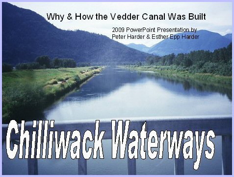
Why & How the Vedder Canal Was Built
by Peter Harder & Esther Epp Harder
|
Waterways: Why and How the Vedder Canal Was Built 1. Let's start with the reasons why the Vedder Canal was built ...
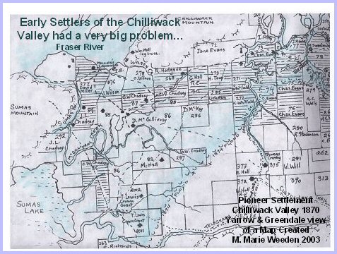
2. Before the Vedder Canal was built, people living in the Fraser Valley had a very big problem. Nature was not very kind to them. Almost every year just when agricultural crops were growing most vigorously, the promising crops were destroyed by a flood resulting in heavy loses and profound discouragement for the struggling farmers. The source of the problem was the Fraser River.
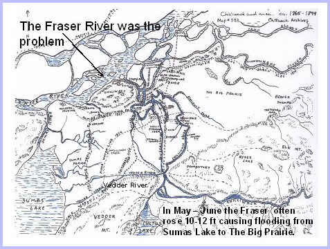
3. It was quite common for the Fraser River to rise 10 - 12 feet when the snow in the mountains would melt during May and June. This sudden rise not only prevented the local rivers and streams from draining into the Fraser but it also caused the Fraser water to back up and flow against stream into the local drainage channels.
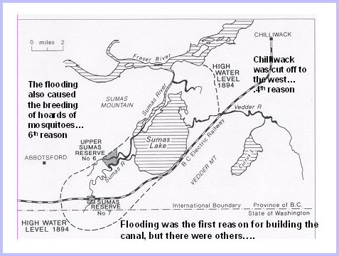
4. The water had nowhere to go but up, causing severe flooding several miles inland from the Fraser. This was first reason for building the canal, but there were others.
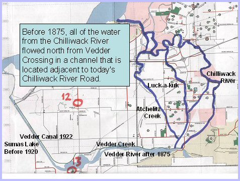
5. The second reason was the tension between the Sumas Flats and the Sardis/Chilliwack communities. The source of the tension was the Vedder River. The Vedder was an unwanted and unwelcome river. Neither community wanted to have this river flowing through the middle of its territory because of its divisive effect. A present day example of this effect would be the barrier between Yarrow and Greendale, these two communities are only meters apart but they might as well be ten miles apart and why? Because a major river has created a barrier.
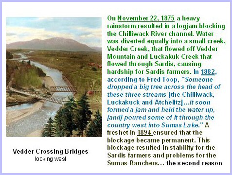
6. At one stage of this quarrel in around 1882 the ranchers of Sumas Flats took matters into their own hands and sent a work crew to Vedder Crossing to make the water flow north through the Vedder/Sardis area. When the Sardis farmers became aware of this exercise, they reported it to the police and demanded that it be stopped. A constable was assigned to investigate. Instead of confronting the crew personally, he hid behind the bushes and fired a few shots hoping this would send the intended message and scare them off, but unfortunately, the officer misjudged the determination of these workers. Instead of dropping their tools and going home, they stormed the bush and ambushed the lone officer and demanded that he serve them with a summons. The shooting had stopped but the tension remained. This fighting between the Sardis farmers and the Sumas ranchers was the second reason for building the canal.
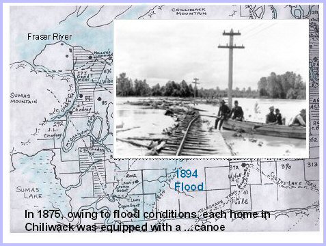
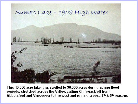
7. The third reason was that flooding was a threat every year ... some floods, such as the one in 1894 were much larger than others. Each spring, Sumas Lake would flood from 10,000 acres to 30,000 acres from the Chilliwack and Vedder rivers flowing into it.
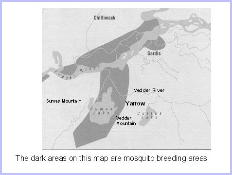
9. The sixth reason: Mosquitoes - A study was conducted by Eric Hearle, Assistant Entomologist in charge of mosquito for the Dominion Department of Agriculture asserted that "the abundance of mosquitoes in the lower Fraser Valley of British Columbia has forces itself upon the notice of all those who have settled there since the first white man to penetrate into the district from the East left his record of the severity of this pest. The dyking and draining of the huge floodwater breeding areas are most important.
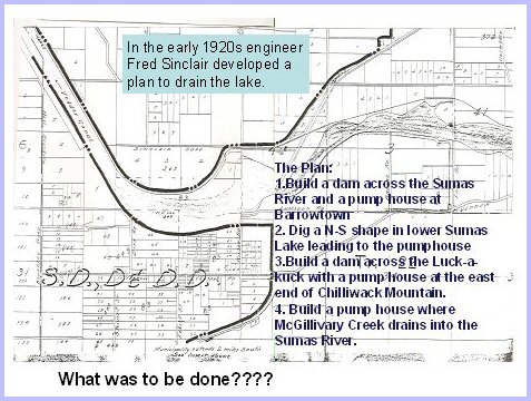
10. So what was to be done? Numerous plans were made, some such as the one by the Lumsden brothers were started but when the high water came, they washed away like sand castles on the seashore and the promoters went broke. In 1917 a petition was circulated which was favourably received, asking the B.C. Government to undertake the project. Fred Sinclair's plan was accepted. This plan was designed to stop Fraser from backing up the Luck-a-kuck and the Sumas Rivers and to stop the flooding of large areas of farmland. After three years of negotiations between the settlers and the Government, tenders were called in March 1920, but because of exceptionally high water from May to September that year, not much work could be done except clearing in the affected areas and some preliminary digging.
11. Barrowtown is a pump station controlling the levels of water in the Sumas River. This reminds us that much of the reclaimed farmland south of here was once the huge Sumas Lake.) Water from rainfall in Chilliwack and Sumas could be managed with pumps during the freshet season, but the large volume of water from the Vedder River could not. Therefore, provision was made for the Fraser water to back up into the Sumas area but to confine it to a narrow strip. This strip was to be the shortest distance between the place where the Vedder emptied into Sumas Lake in Yarrow and where the Sumas River flows directly northward and drains into the Fraser River. By dredging a canal flanked by a high level dyke on each side, Fraser water would be allowed to flood the area between the two dykes but not beyond. During high water, the backed up water could reach as far as the crossing of the Vedder Canal by the BC Electric Railway Bridge. This was also where the high level dykes were to end. So then two canals were planned: The Vedder and the Sumas Canal. The Vedder was to have high level dykes on both sides but the Sumas Canal was to have no dikes. The Vedder Canal drains by force of gravity because it is higher than the Fraser, but the Sumas Canal is lower than the Fraser and therefore has to be pumped into the unprotected part or the Fraser side of the dam across the Sumas River, from where it flows by gravity into the Fraser. During the freshet season the Sumas River water would also have to be pumped to the level of the Fraser on the unprotected side of the dam.
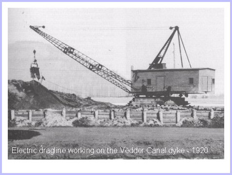
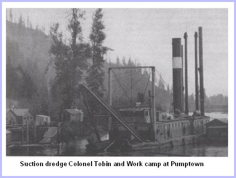
12. The first excavation started in September 1920 with a small dragline dredge working on the east dyke (Greendale side). On November 10th a second dragline dredge with 3 ˝ cubic yard bucket and a 100 foot boom was added, excavating on the Sumas side. To make up for time lost due to the high water, three more dragline dredges were secured as well as one suction dredge.
13. In August 1921, the large suction dredge commenced working on the Vedder Canal starting from the north end. During September and October alone 400,000 cubic yards of earth were moved per month. There was a severe cold spell in December 1921, the ground was frozen to a depth of two feet and ice forming on the canal halted all transportation of supplies and made constant vigilance over the suction dredge necessary to prevent the pipes and pumps from freezing up. These conditions continued until February 1922 and caused the project to fall behind schedule… by the end of February, there were still two miles of dyke to build and they had only three months left until high water time. To speed things up, two more suction dredges were brought in. With this added equipment, crews were able to build up the eastern dyke to a level where it could hold back the floodwaters.
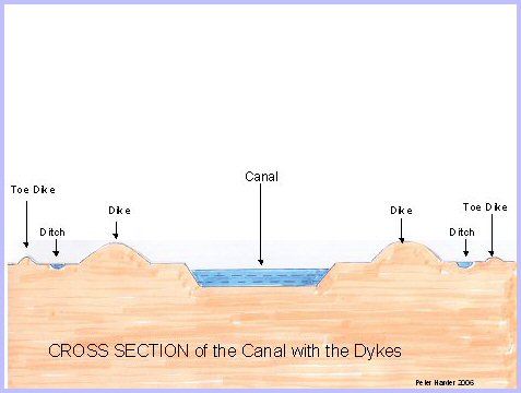
14. The dykes were constructed of earth dug out of the canal and earth from other sources, which would let water seep through during the spring freshet when the water in the canal was high, the ditches were to catch the seepage and the toe dykes were to stop the water from eroding the dyke.
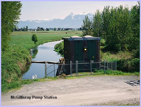
15. The pumps at McGillivray Creek on the Greendale side of the dike were installed and ready to operate when the crews finished building the canal and dykes.
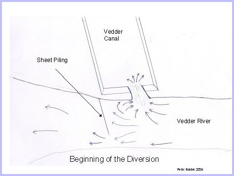
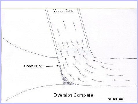
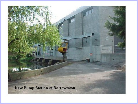
16. The time had come for the real test: to divert the Vedder River water from its natural channel at the bend at Dyke Road (Now No. 3 Road) in Yarrow to the freshly dug canal. This was accomplished by digging a narrow trench from the south end of the canal to a point just a few feet away from the edge of the Vedder River. Three sketches by Peter Harder illustrate how this worked.
17. Next, about thirty feet downstream from this trench, sheet piling was driven almost across the river, which partly blocked the water flow, causing the river to rise. As it rose, the shores of the river moved outward to where the narrow trench was dug. Since this was the lowest part of the bank, the water flowed through the narrow trench into the canal. At first very slowly but with the force of the erosion caused by the running water, this trench quickly opened wide.
18. With only a fraction of the Vedder River now flowing into Sumas Lake, crews were able to block the natural course completely by extending the wall of sheet piling all the way across the current, forcing the full current to erode the last remaining division. By harnessing the forces of nature such as gravity and erosion, crews were able, in the matter of hours, to change the course of the Vedder River and halt its menacing threat. No longer would it be able to flood valuable farmland and create tensions between the two communities.
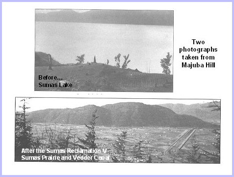
19. Two views from Majuba Hill: Top - before Vedder & Sumas Canals were built, photo shows Sumas Lake and Bottom - after the Canals were built, photo shows the Vedder Canal and the drained farm land.
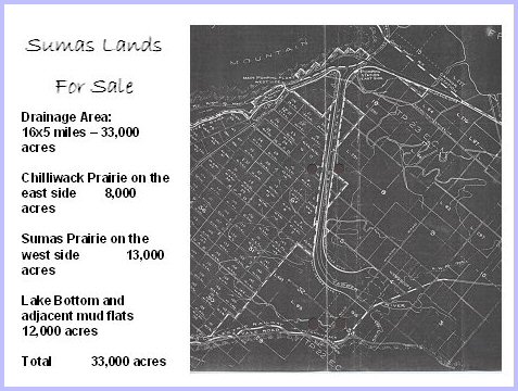
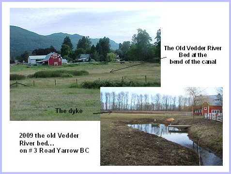
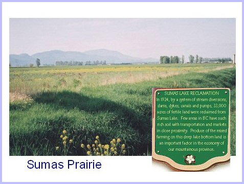
20. Sumas Lands For Sale - Statistics: Drainage Area: 16x5 miles - 33,000 acres; Chilliwack Prairie on the east side - 8,000 acres; Sumas Prairie on the west side - 13,000 acres; Lake Bottom and adjacent mud flats 12,000 acres; Total - 33,000 acres.
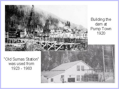
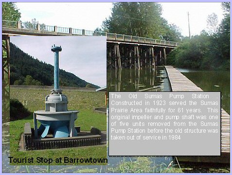
21. The old Sumas Pump Station constructed in 1920 and used since 1923, served the Sumas Prairie area faithfully for 61 years. This original impeller and pump shaft was one of the five units removed from the Sumas Pump Station before the structure was taken out of service in 1984. Background is the bridge on the old Canada #1 Highway, most recently, the westbound lanes of the freeway between Chilliwack and Abbotsford until the bypass was built in 2003.
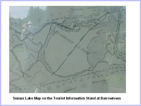
22. This Map is under glass at the information kiosk at the Barrowtown Pump Station shows the placement of both Sumas and Vedder Canals in relation to Sumas Lake. Sumas Canal goes right through the middle of what was Sumas Lake. The land here is below sea level and the water must be pumped.
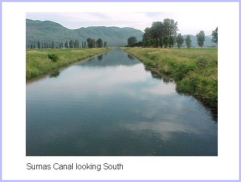
23. Sumas Canal looking south ...
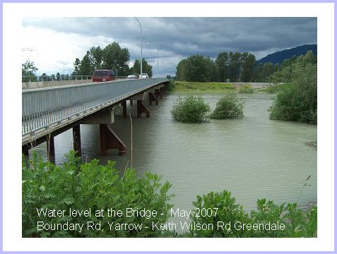
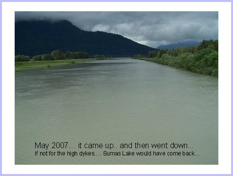
24. The Sumas Pump Station was officially opened in 1985 with a total projected value of $25,450,000. It is jointly operated by the District of Abbotsford and the B.C. Ministry of the Environment. The Pump Station was established as the result of the vast Sumas Reclamation Project, originally carried out by the Sumas Drainage, Dyking and Development District. You can enjoy the picnic area; tours are available but please call in advance. Call 604-823-4678 for more information.
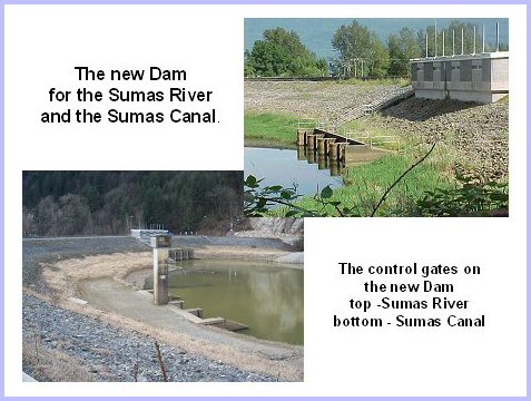
25. The new Dam on the Sumas River and the Sumas Canal and the top gates control the water for the Sumas River and the bottom gates control water levels in Sumas Canal.
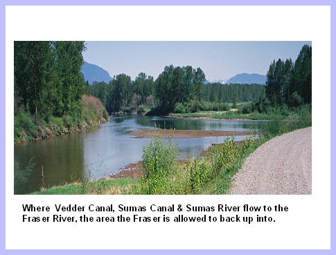
26. Where Vedder Canal, Sumas Canal & Sumas River all run to the Fraser River, this is the area the Fraser is allowed to back up into.
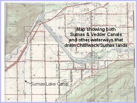
27. Topographical map showing both the Sumas Canal and the Vedder Canal, the site of the Dam and the area that the Fraser River is allowed to back up into and the other waterways in the Yarrow/Sumas area.
28. I grew up in Yarrow and my father told me the stories and showed me where the river used to flow… so I went back in February 2009 to see what remained of the old Yarrow waterways. The slide shows the Yarrow side at the bend in the canal where the Vedder River used to run before the Canal was built…. In 2009, it is hard to find the traces of what was so easy to see in the 1950's ...
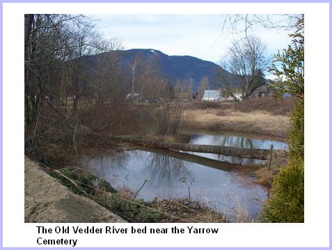
29. The stream meanders along Hare Road to the Yarrow Cemetery. The land for the cemetery, is a little higher than most of the land in Yarrow. Permission for the cemetery at this location was given in May 1931. The slide shows there is still water flowing in the waterway north towards #3 Road.
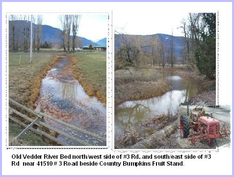
30. In the old river bed, the water flows south to north through a culvert under #3 Road just east of the Country Bumpkins fruit stand, the slide shows both the south and the north side. There were fish in the pond at the south end in the 1950's. The ponds were larger then and we used to ice skate on them when we had very cold weather. The water flows west to the corner of Boundary road and #3 Road. Ponds here are quite small too, and water flows in drainage ditches along #3 Rd to the Sumas Canal.
31. In February, the water in the Vedder Canal is low, with gravel bars showing and men fishing for salmon. It is at least 6 feet down from where I am standing to get to the water, the bank is steep and slippery ... so I choose not to go all the way down, as I have at other times.
32. May 2007 ... I had heard reports that the Vedder canal was rising quickly ... by the time I got there, the water up out of its bed, and it is creeping closer to the top. I can tell that the river levels are being watched. I am thankful the dykes are as high as they are and that patrols are out. Friends who live on the flood plain are making plans and moving their RVs to higher ground.
33. I stood on the bridge between Boundary Road and Keith Wilson Road to take the photo in this slide ... and thought ... if it weren't for the dykes, Sumas Lake would come back ...
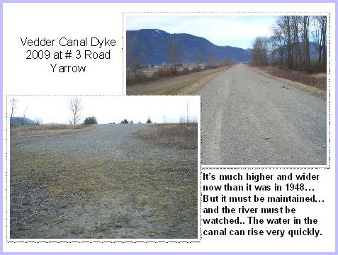
34. The slide shows two views… the bottom is the height of the dyke at the corner of #3 Road, and the top is the width of the dyke looking north. The dykes are well high and well maintained.
35. The Sumas Reclamation project drained approximately 16,000 acres of rich agricultural land and 5,000 acres of steep hillside. Once drained, the Sumas 'Flats', or lake bed, was protected from flooding via the dyke systems. It continues operation today and is responsible for regulating the water levels in the Sumas Prairie. Farmland in the Sumas Prairie is among the most productive in Canada. Early crops in the new land were timothy, clover, tobacco, and later hops. In 2009, the hop and tobacco fields are now planted in corn and daffodils. Large dairy barns with high silos dot the prairie. A four lane highway (that is almost inadequate for the traffic flows it carries) crosses the prairie and even those of us who know; seldom think of the large lake that once covered this area between Abbotsford and the Vedder Canal Bridge.
|


|
Copyright © Elmer G. Wiens: EgwaldTM Web Services
|
